
해로드
100K+
Downloads

Everyone
info

About this app
* The app service for versions 2.9 and lower is '23.2.1. It ended after that. For more information, please check the notices on our center’s website (https://www.nmpnt.go.kr).
Harrod (Sea Road) is a marine information application that anyone can easily install and use on a smartphone running Android 8.0 or higher. You can view your location on the electronic chart for reference, save Points of Interest (POI) and travel route, and record your location you want to keep with the replay function. In addition, it provides useful functions during maritime activities by sending my location in emergency situations and requesting emergency rescue.
*Continued use of GPS in the background may significantly shorten battery life.
main function
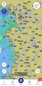
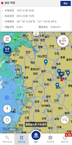
1. View map (electronic chart/Naver map)
- The chart provides reference charts based on electronic charts.
- Naver maps are provided inland areas.
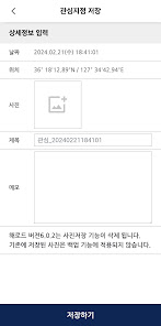
2. Save points of interest/route
- Provides the ability to save your own points of interest and route.
- You can save navigation hazard areas, fishing points, etc. and view them again.
- My movement route is saved in real time even in background mode and can be viewed again.
- Record your location of interest information along with photos.
3. Find your destination
- Find your destination by entering name/longitude/latitude.
- Tap the screen to find a specific location.
- Load saved points of interest.
- Load the saved travel route.
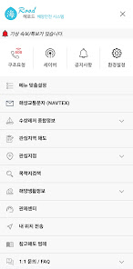
4. Control center connection
- Provides the contact address of a nearby control center and a direct call function.
- Shows the location of maritime traffic control centers by region.
5. Send my location
- Send my location using phone number (contact information)
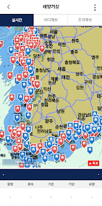
6. Marine weather information
- Weather information required for maritime activities is provided in real time by linking with the relevant agency API.
7. Search for destination
- Provides name search and coordinate search functions.
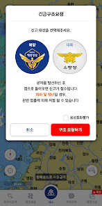
8. SOS function
- Location information transmission function is provided by selecting the Coast Guard (122) and the National Fire Agency (119).
- Provides voice call connection after sending message.
- A retransmission function is provided when a specified interval is separated from the initially requested coordinates.
9. Preferences
- Basic settings (screen off, coordinates/speed/distance units, guide line color, reception environment settings)
- Notification settings (various event notifications)
Harrod (Sea Road) is a marine information application that anyone can easily install and use on a smartphone running Android 8.0 or higher. You can view your location on the electronic chart for reference, save Points of Interest (POI) and travel route, and record your location you want to keep with the replay function. In addition, it provides useful functions during maritime activities by sending my location in emergency situations and requesting emergency rescue.
*Continued use of GPS in the background may significantly shorten battery life.
main function
1. View map (electronic chart/Naver map)
- The chart provides reference charts based on electronic charts.
- Naver maps are provided inland areas.
2. Save points of interest/route
- Provides the ability to save your own points of interest and route.
- You can save navigation hazard areas, fishing points, etc. and view them again.
- My movement route is saved in real time even in background mode and can be viewed again.
- Record your location of interest information along with photos.
3. Find your destination
- Find your destination by entering name/longitude/latitude.
- Tap the screen to find a specific location.
- Load saved points of interest.
- Load the saved travel route.
4. Control center connection
- Provides the contact address of a nearby control center and a direct call function.
- Shows the location of maritime traffic control centers by region.
5. Send my location
- Send my location using phone number (contact information)
6. Marine weather information
- Weather information required for maritime activities is provided in real time by linking with the relevant agency API.
7. Search for destination
- Provides name search and coordinate search functions.
8. SOS function
- Location information transmission function is provided by selecting the Coast Guard (122) and the National Fire Agency (119).
- Provides voice call connection after sending message.
- A retransmission function is provided when a specified interval is separated from the initially requested coordinates.
9. Preferences
- Basic settings (screen off, coordinates/speed/distance units, guide line color, reception environment settings)
- Notification settings (various event notifications)
Updated on
Safety starts with understanding how developers collect and share your data. Data privacy and security practices may vary based on your use, region, and age. The developer provided this information and may update it over time.


App support
About the developer
해양수산부
mofapp1996@gmail.com
다솜2로 94(어진동) 정부세종청사 5동 해양수산부
도담동, 세종특별자치시 30110
South Korea
+82 44-200-5147